Models and Data
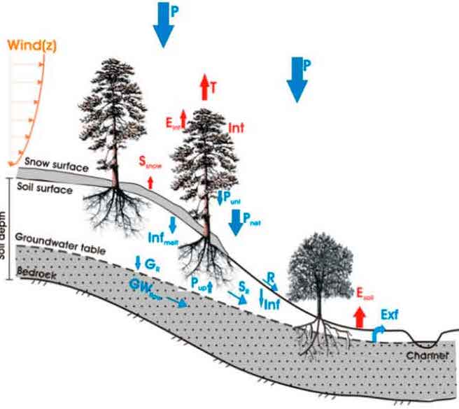
tRIBS Distributed Hydrologic Model
tRIBS is a fully-distributed hydrologic model based on a multi-resolution triangulated irregular network (TIN), developed for the simulation of plot, hillslope, and watershed hydrology. The continuous model preserves high-resolution data from remote sensing and field data for both warm and cold seasons. Model parallelization allows applications in regional basins. Our group uses tRIBS v5.3 as well as the pytRIBS package to conduct studies in desert, forest, and urban areas, as well as for impact assessments of climate and land use change. Model references and H-index are available at CSDMS. Recent model publications include Cederstrom et al. (2024), Raming et al. (2024), and Raming et al. (2025).
VIC Land Surface Hydrology Model
VIC is a macroscale land surface model that uses a grid-based simulation to solve water and energy balances. The regional model is comprised of a three-layer characterization of the soil column and includes subgrid variability in vegetation, soil moisture storage capacity, topography, and precipitation. Streamflow outputs are routed separately using RVIC. Our group has made model improvements for irrigation, urban impervious areas and a clumped evaporation scheme in version VIC 5.1 for use in impact assessments of climate and land use change. We have also improved the application of the model in the Colorado River BBasin through evaluations with ground and remote sensing datasets. Recent model publications include Whitney et al. (2023), Wang et al. (2024), and Yue et al. (2025).

VIC Domain Files: This dataset contains the VIC-5 compatible domain files over the contiguous United States (CONUS) region with the precipitation disaggregation parameters described in Bohn et al. (2019).
NLCD-INEGI Land Cover: The NLCD-INEGI is the harmonized US-Mexico land cover dataset merged from NLCD and INEGI dataset for years 1992, 2001, and 2011.
INEGI Land Cover: The INEGI land cover dataset contains the land cover type over the Mexico that has been harmonized with the NLCD legend for years 1985, 1993, 2002, 2007, and 2011.
MOD-LSP: The MOD-LSP is a gridded land surface parameter set derived from 17 years of MODIS observations and NLCD-INGI land cover classifications over the CONUS region at 0.0625° monthly resolution.
MIRCA-BC-USMX: The MIRCA-BC-USMX dataset contains a spatially explicit mean annual cycle of monthly planted and irrigated fractions at 0.0625 degree (6 km) spatial resolution over the continental United States and Mexico for years 1992, 2002, and 2012.
PITRI: The Precipitation Isosceles Triangle (PITRI) is the two-parameter deterministic approach that members of our team developed and utilize to more accurately estimate hourly diurnal cycles of precipitation from daily datasets.
VIC Scenarios in Central Arizona: This VIC model output dataset contains scenarios of combined effects of future urban growth and climate change on irrigation water use in central Arizona (1-km, hourly resolution from 1981-2100 and aggregated to 30-yr average).
VIC Model Setup and Naturalize Flow in Colorado River Basin: This VIC model setup package contains the source code, parameter set, and USBR natural flow data records for the Colorado River Basin as documented by Mu et al. (2022).
VIC Scenarios for Colorado River Basin: This VIC model output dataset contains scenarios of the precipitation partitioning method in the Colorado River Basin aggregated to 30-yr average for a historical period (1976-2005) and a far future period (2066-2095).
tRIBS Scenarios in Beaver Creek: This tRIBS model setup and output dataset contains scenarios of warming and forest thinning in the Beaver Creek watershed of central Arizona (daily basin average from 2003-2018 water years).
tRIBS Benchmark at Point Scale: This tRIBS model setup and output dataset at the Happy Jack SNOTEL station in northern Arizona serves as a benchmark case for point-scale simulations.
tRIBS Benchmark at Basin Scale: This tRIBS model setup and output dataset at the Big Spring watershed in northern Arizona serves as a benchmark case for basin-scale simulations.
tRIBS Zenodo Release v5.2: This tRIBS code package provides v5.2 and associated tools, as documented by Raming et al. (2024): A multi-resolution, parallel platform for tributary hydrology in forest applications.
pytRIBS Example at Basin Scale: This JupyterLab Notebook documents an end-to-end workflow with pytRIBS for setting up, executing, and analyzing a tRIBS 5.2 simulation in the Newman Canyon, AZ, USA as part of Raming et al. (2024).
2008-2012 Study in central Sonora, MX: Meteorological and ecosystem flux data for climate change impacts on net ecosystem productivity in a subtropical scrubland of northwestern México
2015 Phoenix, Arizona, Urban Study: Water, energy and carbon fluxes and ancillary meteorological measurements of four different urban landscapes in Phoenix, AZ
2017 NAM Study in central Sonora, MX: Flux and precipitation data from the North American Monsoon GPS Hydrometeorological Network 2017
2018-2020 Encanto and Paradise Valley Parks, Phoenix Study: Precipitation, soil water content and reference evapotranspiration at two urban parks in Phoenix, Arizona during 2018-2020.
2019-2020 Encanto Park, Phoenix Study: Water, energy and carbon fluxes as wells as ancillary meteorological and NDVI measurements from the Encanto Park Golf Course in Phoenix, AZ
2010-2020 AmeriFlux Site at Jornada Experimental Range: Water, energy and carbon fluxes at a long-term tower site within a mixed shrubland experimental watershed in southern NM
2011-2020 AmeriFlux Site at Santa Rita Experimental Range: Water, energy and carbon fluxes at a long-term tower site within a mesquite savanna experimental watershed in southern AZ
Hydrological Processes Data Note (Vivoni et al. 2021): Hydrologic data from long-term research catchments at the Santa Rita and Jornada Experimental Ranges
Flowing days Derived from CubeSat Imagery (Wang and Vivoni, 2022): Streamflow presence derived from small satellite imagery and ground observations in the Hassayampa River, Arizona from 2019-2021 (water years)
2016-2022 Playa Water Level at Jornada Experimental Range: Long-term water level observations at 18 instrumented ephemeral lakes or playas in southern NM
2024-present AmeriFlux Site in Phoenix (US-Px1): Urban water, energy and carbon fluxes at Maryvale Neighborhood Site as part of the Southwest Urban Corridor Integrated Field Laboratory (SW-IFL)
2024-present AmeriFlux Site in Phoenix (US-Px2): Urban water, energy and carbon fluxes at Encanto Golf Course as part of the Southwest Urban Corridor Integrated Field Laboratory (SW-IFL)
2024-present AmeriFlux Site in Phoenix (US-Px3): Urban water, energy and carbon fluxes at Desert Botanical Gardens as part of the Southwest Urban Corridor Integrated Field Laboratory (SW-IFL)
2024 AmeriFlux Site in Phoenix (US-Px4): Urban water, energy and carbon fluxes at Encanto Vehicle Lot as part of the Southwest Urban Corridor Integrated Field Laboratory (SW-IFL)
2025-present AmeriFlux Site in Phoenix (US-Px5): Urban water, energy and carbon fluxes at ASU Polytechnic Campus as part of the Southwest Urban Corridor Integrated Field Laboratory (SW-IFL)
pytRIBS: A pre-to-post processing Python package designed to allow users to setup, simulate, and analyze TIN-based Real-time Integrated Basin Simulator (tRIBS) model runs through a Python interface.
NLCD-INEGI Creation Scripts: Scripts used to generate the NLCD_INEGI: Harmonized US-Mexico Land Cover Classifications from NLCD and INEGI, 1992/2001/2011 (Bohn et al. 2018).
MOD-LSP Creation Scripts: Scripts used to create the first version of MOD-LSP VIC parameters over the continental United States, Mexico, and Southern Canada for the VIC model (Bohn et al. 2018).
PITRI Creation Scripts: Scripts used to create the triangular distribution of precipitation over the continental United States (Bohn et al. 2019)